 to add an item to your Itinerary basket.


Book Tickets Online
About
Black Rock Picnic Site is great place to rest your legs, offering panoramic views of the Severn Estuary and both Severn Bridge Crossings. It also offers parking if you wish to base yourself here for walks along the Wales Coast Path.
Landmarks
Look around you at the different landmarks. Facing towards the water, the Severn Bridge (to you left) was opened in 1966 and with increasing traffic, the Second Severn Crossing (to your right) was built and opened in 1996. It was renamed the Prince of Wales Bridge in 2018. The tall square brick building to the right of the second bridge is a pumping station that pumps water out of the Severn Tunnel.
Ferry
Two hundred years ago, goods and people had to be ferried across the estuary by boat from Black Rock. This crossing point was used by the Romans and Normans, and as early as 1138 a ferry brought monks, servants and cattle from England across the river. The boat journey was very hazardous due to the strong currents, the weather and the varying tides. From 1863 a railway line stopped on Portskewett Pier at Black Rock. People got off a steam train and took a steamboat to a connecting train at New Passage across the river. The ferry crossing stopped in 1886 with the opening of the Severn Rail Tunnel, allowing passengers to remain on steam trains travelling under the River Severn. Trains between Wales and England still travel through this tunnel.
Book Tickets
Related
 Health Walk - Black Rock Walk, CaldicotA 3 mile walk from Black Rock picnic area, using a section of the Wales Coast Path.
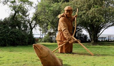
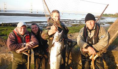 Black Rock Lave Net Heritage Fishery, CaldicotThe lave net fishermen of Black Rock promote the fishery as a heritage site and invite all to enjoy this last remaining welsh severn estuary salmon fishery which can be watched quite safely from the picnic site.
Facilities
Booking & Payment Details
- Free Entry
Parking
- Free Parking